Highlights
- New oxide gold discoveries in Arizona USA, a top-tier mining jurisdiction.
- 4 kilometre mineralized trend, open along strike.
- Known mineralized zones are being expanded and new target areas are being tested.
- New drill discovery at WestGold in 2023 including 0.7 g/t gold over 35 metres including 2.5 g/t gold over 7.6 metres.
- Over 138 drill holes completed, highlights include:
- 1.0 g/t gold over 59.5 metres from surface
- 1.0 g/t gold over 48.8 metres from surface
- 1.8 g/t gold over 19.8 metres from 38.1 metres depth
- 1.1 g/t gold over 27.4 metres from 33.5 metres depth
- 0.9 g/t gold over 44.2 metres from 35.1 metres depth
- 0.8 g/t gold over 27.4 metres from 33.5 metres depth
- 0.6 g/t gold over 30.5 metres from 12.2 metres depth
- 1.6 g/t gold over 35.1 metres from surface
- 2.2 g/t gold over 24.4 metres from 10.7 metres depth
- 2.2 g/t gold over 18.3 metres from 16.8 metres depth
- 8.2 g/t gold over 4.6 metre from 19.8 metres depth
- 5.9 g/t gold over 4.6 metres from 3.1 metres depth
- 14.1 g/t gold over 1.5 metres from 21.3 metres depth
Introduction
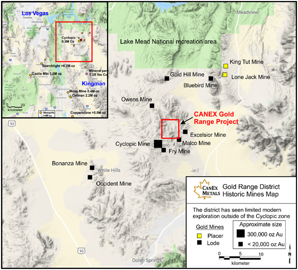
The Gold Range property is located in Mohave County Arizona within a historic district that has seen widespread small-scale lode and placer gold production but limited modern lode gold exploration. The property consists of 261 lode mining claims located on federal land administered by the Bureau of Land Management and 2 mineral patents. CANEX has staked 246 of these claims and entered into 3 option agreements covering 15 lode mining claims and 2 patents.
Geology and Mineralization
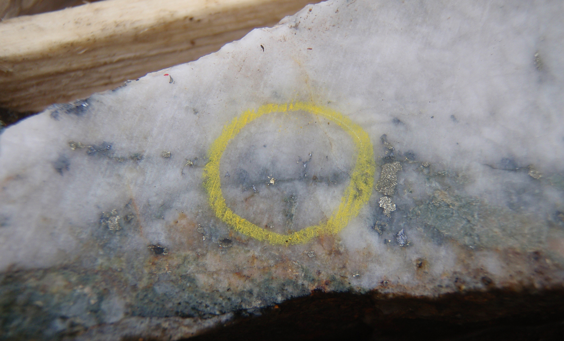
The Gold Range district contains Precambrian metamorphic rocks that have been intruded by Cretaceous granites and modified by Laramide to Tertiary age compression and extension. Most mineralized veins are mesothermal in nature and contain trace to a few percent sulfides consisting of galena, chalcopyrite, pyrite and sphalerite, and traces of native gold.
The Gold Range Property contains multiple historic workings dating back as far as the 1880’s but very limited modern exploration and to our knowledge the claim area has never been assembled and explored in the context of a single large mineralized system. CANEX is focused on identifying zones within this large system that have potential to host large, near surface, oxide gold deposits.
Numerous high-grade gold bearing quartz veins occur over an area 5 kilometres by 3 kilometres with gold grades ranging from trace to 94.7 g/t. The average of 367 surface chip and grab samples, including mineralized veins and barren wall rock, is 4.4 g/t gold. Individual high grade gold veins on the property can be traced over hundreds of meters and typically pinch and swell along strike and down dip. The larger vein systems contain halos of sheeted and stockwork veins with good width and continuity, and are being evaluated for their potential to host bulk tonnage oxide gold mineralization with associated high grade zones.
Significant intercepts of oxide gold mineralization have now been encountered at the Excelsior, Eldorado, Malco, Central, and Shaft zones, which remain open for expansion along strike and to depth.
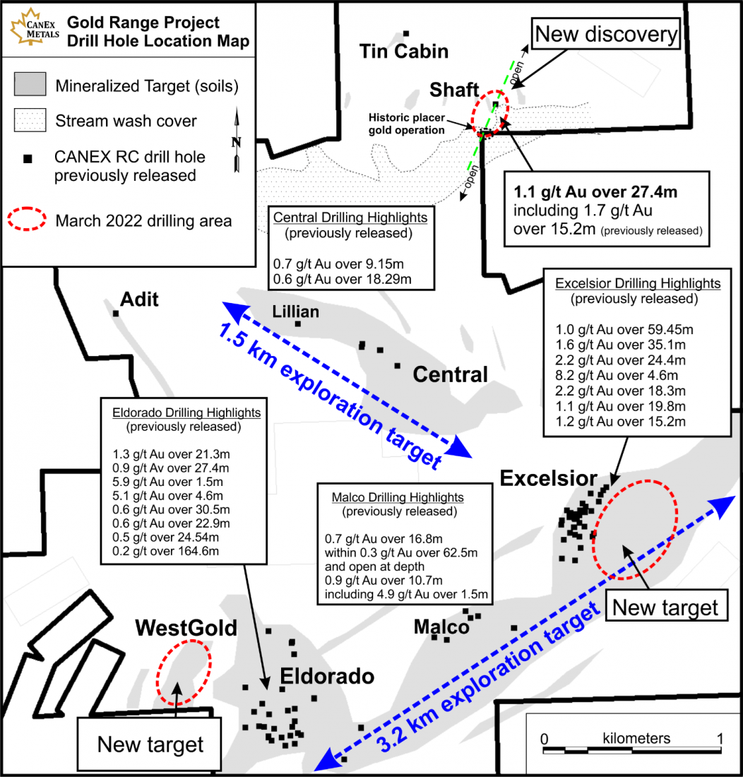
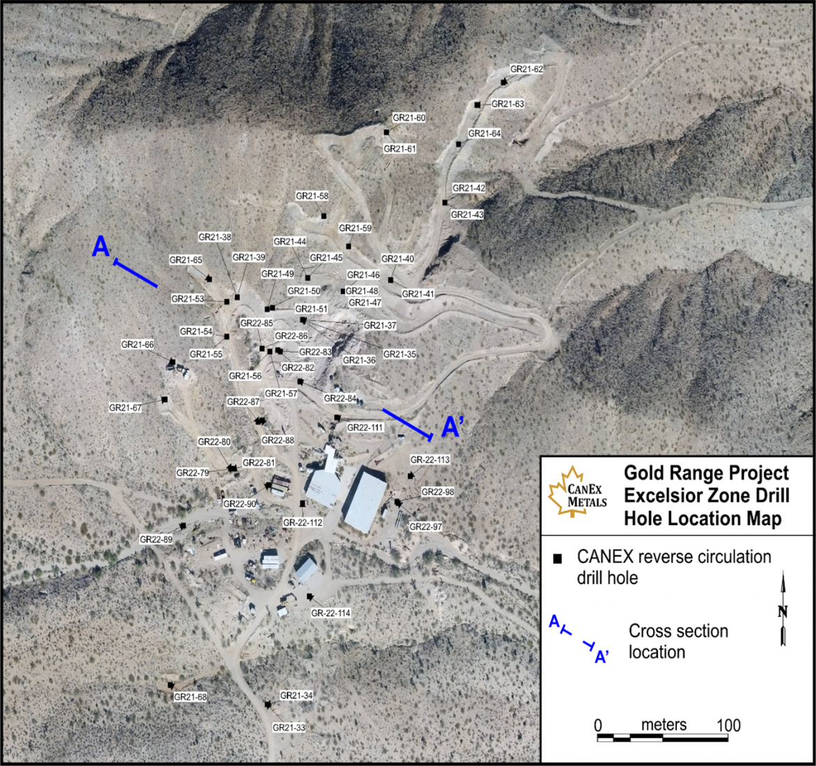
Gold Range Property drill hole location map showing mineralized target areas and known zones, and zones scheduled for drill testing.
Table of Select Drill Hole Results from the Gold Range Project
Drill Hole | From (m) | To (m) | Width (m)* | Au g/t | Zone |
GR20-4 | 3.05 | 7.62 | 4.56 | 5.9 | Eldorado |
GR20-8 | 1.52 | 25.91 | 24.39 | 0.5 | Eldorado |
GR20-9 | 1.52 | 166.12 | 164.6 | 0.2 | Eldorado |
GR20-9 | 1.52 | 51.82 | 50.3 | 0.5 | Eldorado |
GR20-9 | 3.05 | 48.77 | 45.72 | 0.5 | Eldorado |
GR20-9 | 6.1 | 33.53 | 27.43 | 0.9 | Eldorado |
GR20-9 | 6.1 | 24.38 | 18.28 | 1.0 | Eldorado |
GR20-9 | 6.1 | 21.34 | 15.24 | 1.1 | Eldorado |
GR20-13 | 10.67 | 32.00 | 21.33 | 0.6 | Eldorado |
including | 21.34 | 28.96 | 7.62 | 1.2 | Eldorado |
GR21-18 | 15.2 | 38.1 | 22.9 | 0.6 | Eldorado |
including | 22.9 | 38.1 | 15.2 | 0.7 | Eldorado |
GR21-25 | 54.9 | 76.2 | 21.3 | 1.3 | Eldorado |
including | 54.9 | 59.4 | 4.6 | 5.1 | Eldorado |
GR21-31 | 74.68 | 137.16 (EOH) | 62.5 | 0.3 | Malco |
GR21-31 | 86.87 | 103.63 | 16.8 | 0.7 | Malco |
GR21-32 | 42.67 | 53.34 | 10.7 | 0.9 | Malco |
GR21-36 | 15.24 | 35.05 | 19.8 | 1.1 | Excelsior |
including | 15.24 | 21.34 | 6.1 | 2.8 | Excelsior |
GR21-37 | 0.00 | 35.06 | 35.1 | 1.6 | Excelsior |
including | 10.67 | 35.06 | 24.4 | 2.2 | Excelsior |
including | 19.81 | 24.38 | 4.6 | 8.2 | Excelsior |
including | 21.34 | 22.86 | 1.5 | 14.1 | Excelsior |
GR21-38 | 33.53 | 60.96 EOH | 27.4 | 0.8 | Excelsior |
including | 39.62 | 60.96 EOH | 21.3 | 1.0 | Excelsior |
including | 42.67 | 60.96 EOH | 18.3 | 1.2 | Excelsior |
GR21-42 | 10.67 | 24.38 | 13.71 | 1.1 | Excelsior |
GR21-43 | 12.19 | 22.86 | 10.67 | 1.1 | Excelsior |
GR21-44 | 27.43 | 33.53 | 6.1 | 0.5 | Central |
GR21-45 | 28.96 | 48.77 | 19.81 | 1.1 | Excelsior |
GR21-46 | 16.76 | 35.05 | 18.29 | 2.2 | Excelsior |
including | 19.81 | 30.48 | 10.67 | 3.4 | Excelsior |
GR21-47 | 7.62 | 22.86 | 15.24 | 1.2 | Excelsior |
GR21-49 | 28.96 | 51.83 | 22.87 | 0.5 | Excelsior |
GR21-57 | 0 | 59.45 | 59.45 | 1.0 | Excelsior |
including | 27.44 | 59.45 | 32.01 | 1.4 | Excelsior |
including | 27.44 | 28.96 | 1.52 | 9.5 | Excelsior |
GR21-59 | 38.11 | 57.93 | 19.82 | 1.8 | Excelsior |
including | 39.63 | 47.26 | 7.63 | 4.1 | Excelsior |
GR21-63 | 25.91 | 48.78 | 22.87 | 0.5 | Excelsior |
GR21-73 | 12.2 | 42.68 | 30.48 | 0.6 | Eldorado |
GR22-82 | 0 | 48.78 | 48.78 | 1.0 | Excelsior |
including | 38.11 | 39.63 | 1.52 | 9.7 | Excelsior |
GR22-83 | 35.06 | 79.27 | 44.21 | 0.9 | Excelsior |
including | 39.63 | 50.3 | 10.67 | 2.7 | Excelsior |
GR22-85 | 13.72 | 22.87 | 9.15 | 2.4 | Excelsior |
including | 18.29 | 19.82 | 1.53 | 9.0 | Excelsior |
GR22-86 | 60.98 | 79.27 | 18.29 | 0.5 | Excelsior |
GR22-90 | 33.54 | 45.73 | 12.19 | 1.2 | Excelsior |
including | 36.59 | 41.16 | 4.57 | 2.7 | Excelsior |
GR22-110 | 33.54 | 60.98 EOH | 27.44 | 1.1 | Shaft |
including | 36.59 | 51.83 | 15.24 | 1.7 | Shaft |
including | 48.78 | 50.3 | 1.52 | 7.6 | Shaft |
*Drill hole intercepts, true widths have not been determined. Grades have not been capped in the averages. EOH = end of hole.
Excelsior is the most advanced gold zone on the property. To date 52 reverse circulation drill holes have tested Excelsior defining a mineralized zone that is 350 metes long, 20 to 100 metres wide, and extending 75 to 100 meters deep. The zone remains open along strike and to depth.
Excelsior Zone drill hole map.
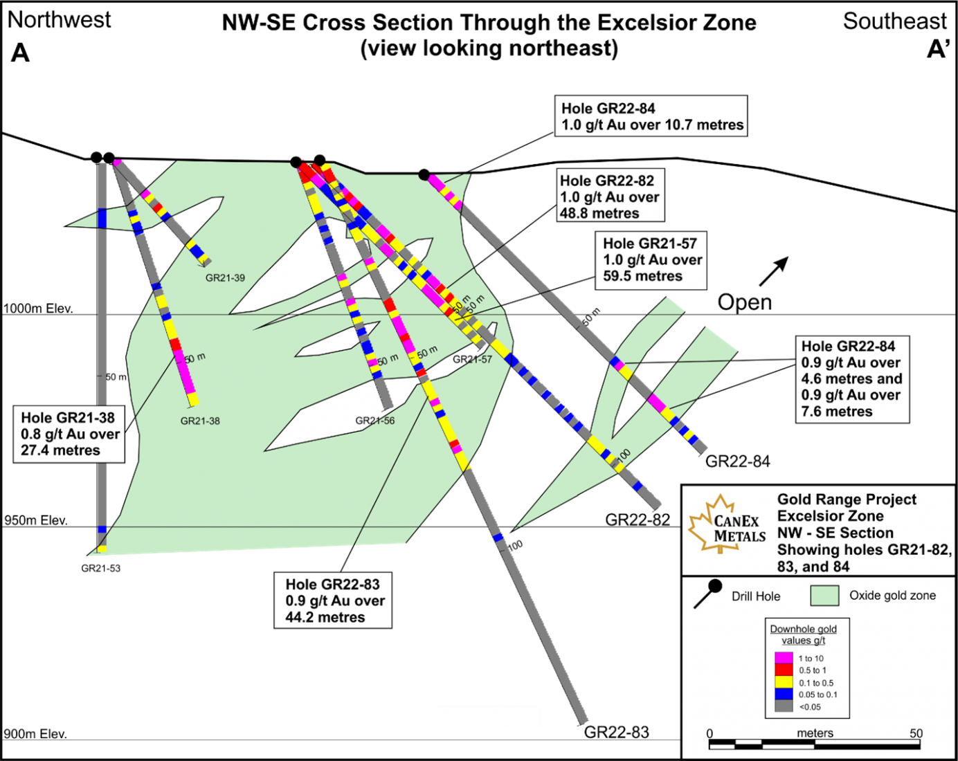
Cross section through the Excelsior Zone showing gold grades. See the Excelsior drill hole map for section location.
Early stage metallurgical test work indicate the oxide gold zones at Gold Range have excellent leach characteristics. Results from 8 bottle roll tests on drill samples across the system and from different depths returned 94 to 99% cyanide soluble gold, averaging 97%.
New Targets and Next Steps
Fieldwork conducted in 2022 and 2023 has recognized multiple new targets that will be drill tested shortly. At Excelsior 3 to 4 parallel mineralized zones have been identified immediately east of the known deposit. These zones return strong gold grades at surface, have been traced for up to 600 metres along strike, and remain open in both directions.
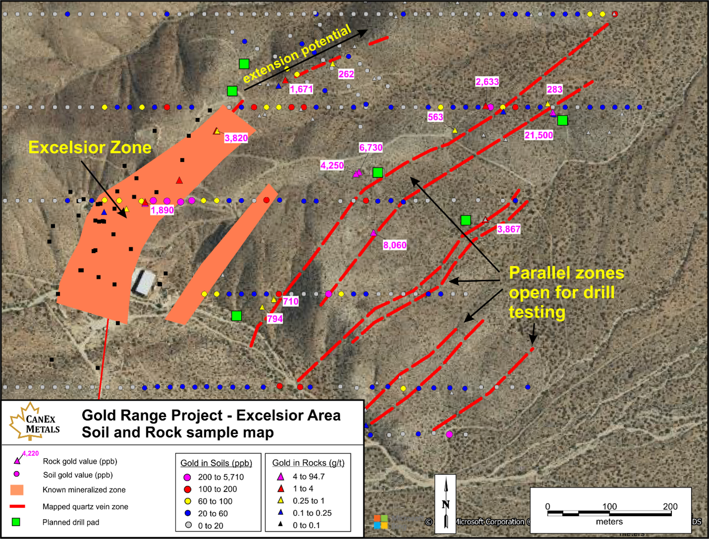
Map of the Excelsior area showing mineralized zones and targets.
The WestGold target contains the strongest gold in soil anomaly on the project and has never been tested by drilling. The anomaly is 400 metres long by up to 150 metres wide with gold in soil values ranging from 0.1 to 0.6 g/t gold.
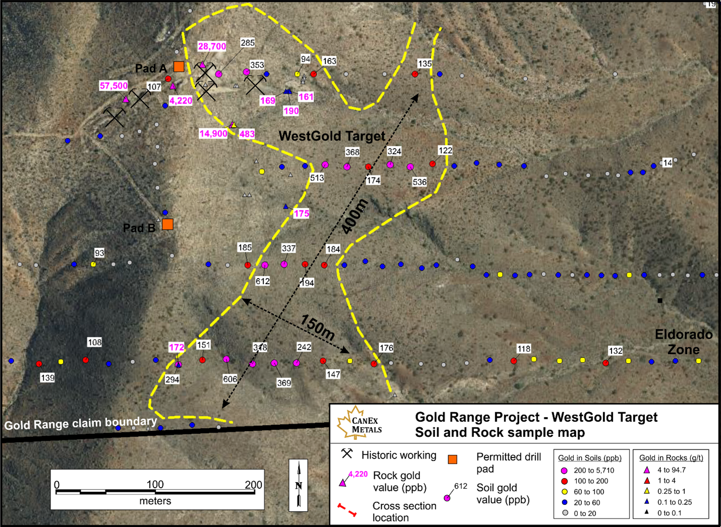
Map of the WestGold Target showiong gold in soils and rocks.
CANEX remains focused on unlocking the potential of the Gold Range project by identifying and outlining zones with gold resource potential. All our current oxide gold discoveries remain open along strike and to depth and will continue to be expanded through drilling. New targets are continuously being generated and advanced with those showing potential for scale and grade to be be systematically drill tested.